A new class of AI systems is quietly changing how scientists understand one of nature’s most unpredictable threats: ground failure. From landslides in Nepal to avalanches in the Alps, researchers are now using machine learning to detect early warning signals that were previously invisible, turning slow geological shifts into actionable alerts.
At the center of this work is research led by Antoinette Tordesillas, whose team is developing AI models that can identify unstable terrain long before collapse occurs. The approach combines satellite data, physics-based modeling, and machine learning to map risk zones with increasing precision.
Landslides and avalanches remain among the most difficult natural disasters to predict.
Unlike earthquakes or storms, they often lack clear, immediate triggers. Slopes can remain stable for years and then suddenly fail, often after a combination of rainfall, temperature shifts, or internal structural weakening.
Globally, these events:
Climate change is increasing the frequency of these events by altering rainfall patterns and destabilizing mountain ecosystems.
The challenge has always been visibility. The warning signs exist, but they occur at a scale too subtle for traditional monitoring.
The breakthrough lies in combining satellite radar imaging with machine learning.
AI systems ingest massive datasets that include:
These datasets are far too large and complex for manual analysis. AI models process them continuously, identifying patterns that signal instability.
At a technical level, the system looks for micro-movements in the ground. These are tiny shifts in soil and rock structure that occur over time.
When particles begin to move in ways that match known failure patterns, the AI flags the area as high risk.
This transforms slow, invisible processes into visible signals.
One of the most practical outputs of these systems is the creation of color-coded risk maps.
These maps highlight:
Instead of raw scientific data, communities and authorities receive simplified visual outputs that can guide decision-making.
This is a critical shift.
Traditional monitoring systems often require expert interpretation. AI-driven mapping makes the information accessible to local governments, planners, and even residents.
The technology is already being tested in high-risk regions.
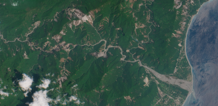
In Kimtang village in central Nepal, AI analysis revealed a large unstable zone beneath the settlement.
The findings showed that homes and farmland were sitting on terrain with a high likelihood of landslide activity.
For communities like Kimtang, this kind of insight is transformative. It allows authorities to:
In Tyrol, similar AI-driven systems are being applied to snowpack analysis.
These systems combine:
The goal is to predict when snow layers become unstable enough to trigger avalanches.
This is particularly important for ski regions and mountain communities where avalanche risk is both seasonal and economically significant.
Early warning is not just about saving lives. It also has major economic implications.
| Impact Area | Without AI | With AI Early Warning |
|---|---|---|
| Disaster Response | Reactive | Preventive |
| Infrastructure Damage | High | Reduced |
| Evacuation Planning | Last-minute | Pre-planned |
| Monitoring Costs | Labor-intensive | Automated at scale |
By identifying risks earlier, governments can shift from emergency response to long-term planning.
This reduces both human and financial losses.
Despite its promise, AI-based prediction is not a perfect solution.
There are still limitations:
This means these systems are best used as decision-support tools rather than definitive predictors.
As climate change increases environmental instability, the role of AI in disaster prediction is expanding.
The same principles used for landslides and avalanches are now being applied to:
This signals a broader shift in how environmental risks are managed.
Instead of relying solely on historical data, AI allows for continuous, real-time analysis of evolving conditions.
The most important shift brought by these systems is not just technological. It is practical.
For the first time, communities can see risks that were previously hidden.
Instead of reacting after disaster strikes, they can:
The work led by researchers like Antoinette Tordesillas shows how AI can bridge the gap between complex scientific data and real-world decision-making.
Natural disasters will never be fully predictable. But they are becoming more understandable.
AI systems that detect early signs of ground movement represent a shift from uncertainty toward probability. They do not eliminate risk, but they make it visible. In regions where a single landslide can destroy entire communities, that visibility can make the difference between survival and catastrophe.
As these systems improve and scale globally, they are likely to become a core part of how governments and communities manage environmental risk in the decades ahead.
Be the first to post comment!